

 Introduction
PGOLID has an extensive data set from its monitoring programs. The lake monitoring program was started in 1996, and has resulted in consistent data from 1996 to 2020. The stream monitoring program was started in 2001 and has resulted in consistent data from 2001 to 2020. This data was inputted to a BATHTUB computer model (US Army Corps of Engineers) to determine the proportion of phosphorus loading from different sources to the lake. These results can be used to implement programs to improve or maintain the water quality by addressing the phosphorus sources. Potential phosphorus sources include septic systems, shoreline runoff, precipitation, internal loading and inlet loading.
Results
The model output for each lake shows the percentage of phosphorus loading from each of the different sources (Figure 1). Little Pelican, Pelican, and Fish Lakes look somewhat similar because they have major inflows from the Pelican River. Overall, the largest source of phosphorus loading to the lakes is the inlets, especially the Pelican River. Septic systems and shoreline runoff are minimal in comparison to the inlets.
Bass Lake looks different from the other lakes because it is fairly isolated, with no major inlets. The connection between Bass and Fish Lakes does not appear to move much water back and forth, but there is undoubtedly some exchange (~11%). Therefore, the septic systems and shoreline runoff have a larger proportional impact in Bass Lake than the other PGOLID lakes (Figure 1).
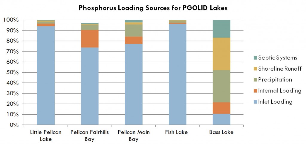
Figure 1. Phosphorus loading sources for the PGOLID lakes.